 Freelance
Traveller
Freelance
TravellerTravellerMap’s Atlas of the Imperium: Second Survey
This article originally appeared in the November/December 2019 issue.
 The
Atlas of the Imperium: Second Survey. generated by TravellerMap.com
(code by Joshua Bell).
The
Atlas of the Imperium: Second Survey. generated by TravellerMap.com
(code by Joshua Bell).
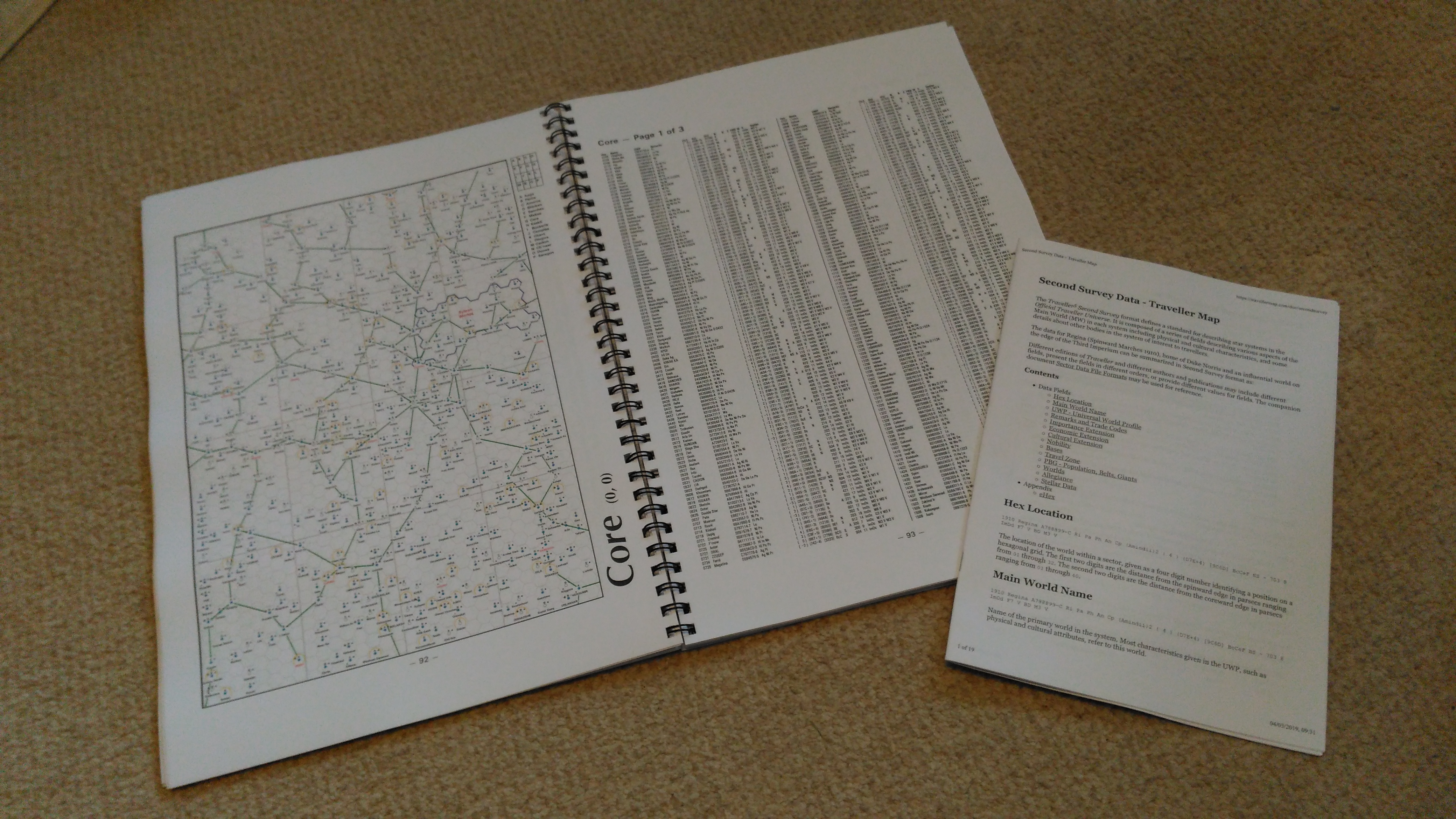
TravellerMap.com https://travellermap.com/make/atlas
210pp., PDF
Free
Editor’s note: US and International paper sizes are somewhat different. Some near-equivalents: International A4 corresponds roughly to US Letter; A3 to Tabloid (e.g., NY Post or National Enquirer newspaper) or Ledger; A2 to Broadsheet (e.g., NY Times or Wall Street Journal newspaper); and A5 to Steno (roughly the size of the original (Classic) Traveller ‘Little Black Books’).
There’s nothing Travellers seem to like more than a good map, whether it’s your standard world map to give a sense of place, a local area map to plan combat, a deck plan or building plan to break into or out of the next ship/starport/museum/warehouse, or astrographic maps to choose travel routes and get a sense of the scale of the universe. Referees love creating them and players always seem to welcome them on the table to give a focus to their imaginations and decision making.
Travellermap.com takes this to nth degree with its fabulous array of options to display everything from the galaxy through Charted Space and sectors to individual worlds and Jump maps or even a planetary surface map. Ironically, it’s possible to get lost here for hours. In addition, data across multiple milieux is available and posters/booklets can be made from the data.
That’s all very well if you’re online, of course, but what if you’re away from the internet – yes, it does still happen – or you just want to spend a lazy Sunday afternoon, sitting in comfort, browsing through the universe and travelling in your mind without sitting at a screen? That’s where the atlas comes in. Long time Traveller fans may recall The Atlas of the Imperium from GDW, which, at the time, was impressive in its scope, but rather disappointing in its actual detail. Or lack of it. Just the system positions and no data.
 However, that’s all changed. Joshua Bell and his TravellerMap have
finally given us the atlas we’ve long dreamed about:
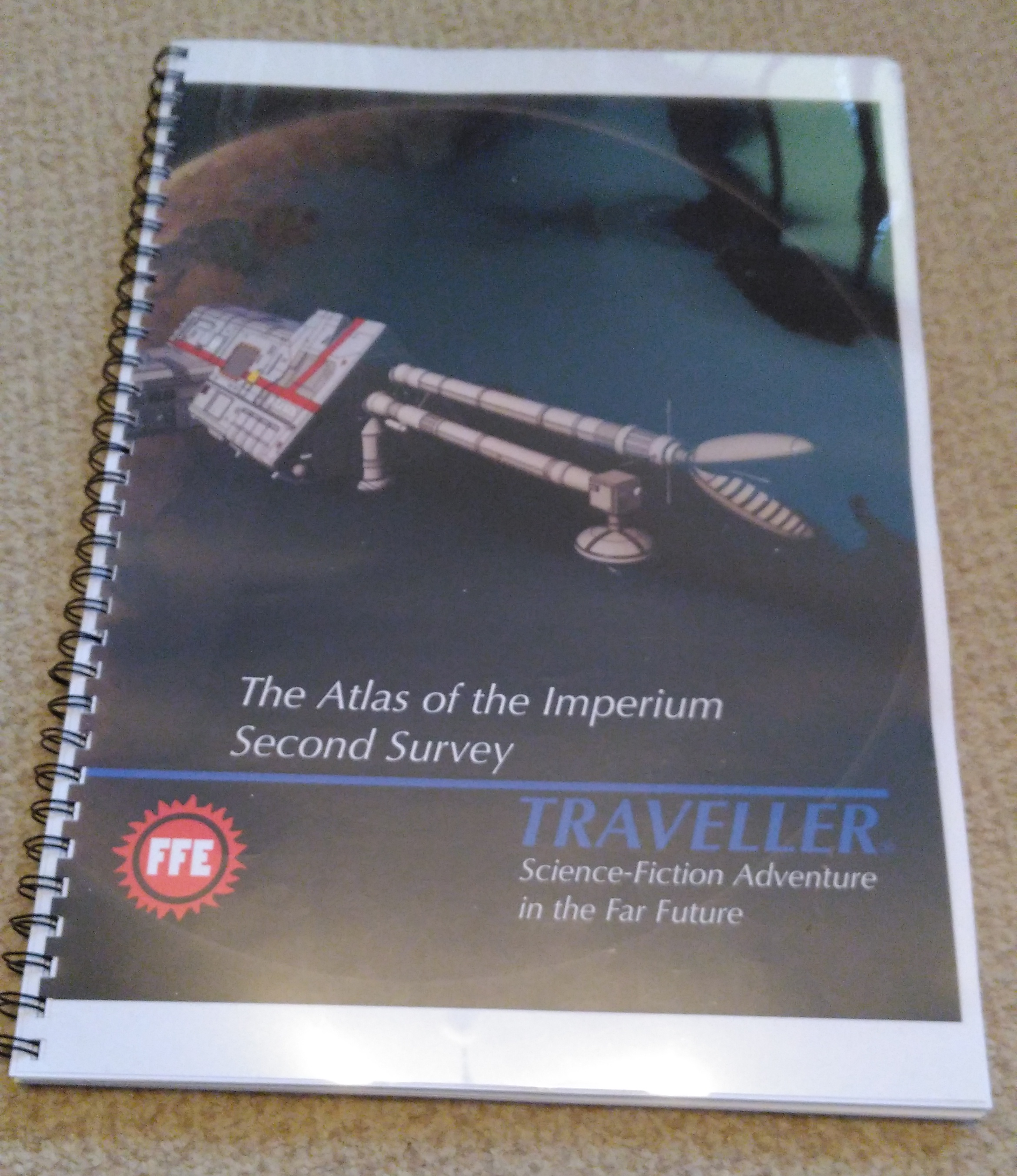
The Atlas of the Imperium: Second Survey (although it actually covers much more than the Imperium.) It
is a wonderful 210-page PDF with colour throughout, and a terrific Ian
Stead wraparound cover (front and back), also in colour. There is a one-page chapter entitled ‘Mapping the Imperium’ which gives a brief in game
history and some notes on using the atlas with a key to the maps and the
data. A three-page credits section details where the data is from and
who is responsible. There is also an index and a sector diagram of
Charted Space. The latter shows systems positions (i.e., sector dot
maps), sector names, polities in various colours and highlights the
sectors included in the atlas. The diagram covers 128 sectors (from -8,3
to 7,-4) and the atlas itself contains 64 of these in detail.
However, that’s all changed. Joshua Bell and his TravellerMap have
finally given us the atlas we’ve long dreamed about:
The Atlas of the Imperium: Second Survey (although it actually covers much more than the Imperium.) It
is a wonderful 210-page PDF with colour throughout, and a terrific Ian
Stead wraparound cover (front and back), also in colour. There is a one-page chapter entitled ‘Mapping the Imperium’ which gives a brief in game
history and some notes on using the atlas with a key to the maps and the
data. A three-page credits section details where the data is from and
who is responsible. There is also an index and a sector diagram of
Charted Space. The latter shows systems positions (i.e., sector dot
maps), sector names, polities in various colours and highlights the
sectors included in the atlas. The diagram covers 128 sectors (from -8,3
to 7,-4) and the atlas itself contains 64 of these in detail.
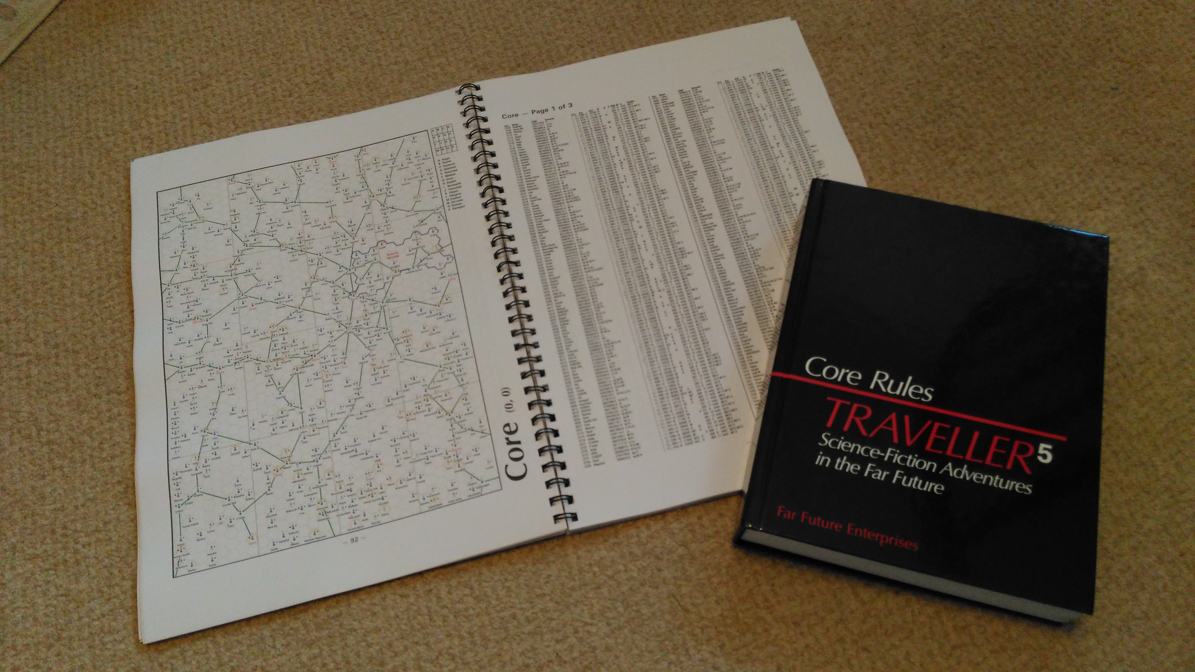
How much detail? The core of The Atlas of the Imperium: Second Survey is – for each sector – a nearly full page colour sector map with a margin that includes the sector name, the coordinate location in the style used above, and a diagram/list showing the sixteen subsectors (which are also marked on the map but not with names). For each sector there is then one to three pages of system data depending on how sparse or full the sector is. This data includes not only the standard Traveller UWPs etc, but also the extended Traveller5 information; this is presented in two columns and when printed at A3 (roughly twice US Letter size) is reasonably readable. For certain sectors such as Foreven, long set aside as a referee preserve, there is very little data and just the dot positions of the stars.
In short, there is a wealth of material here and it’s wonderful to be able to browse through it, imagine worlds, plan journeys, and take inspiration from the wondrously vast Charted Space to think up any number of new adventures. Yes, of course, you can do this on the website, but for some of us there’s an added attraction of being able to do it appreciate this rich tapestry away from the internet and a screen.
So much so that I’d long contemplated producing something along these lines myself. Just printing the sector maps at the largest size I could, printing the data booklets and binding it altogether. Thanks to my plans to run at least one Zero Prep game at this year’s TravCon (Freelance Traveller, May/June 2019, p.32), I’d actually set off on this project and had begun to save the first of the sectors I thought I’d include. I had done some experimentation and seen that printing a sector in colour (but not on a black background) at A3 size meant a map that was quite usable even with aging eyesight. I couldn’t quite squeeze on the UWPs at that size – although TravellerMap allows the possibility – but I can’t easily print at the next size up, A2, and didn’t particularly want to start sticking together two sheets of paper. My plan was to take a reasonable chunk of Charted Space, maybe 125 sectors worth, print out the maps and bind them together to make an atlas. It would have been a bit rough and ready however as there’d be no sector title on each map unless I added it manually, pages would be printed single sided which would bulk the thing out, I’d lose sections of the map along the binding edge, and I’d have the UWPs separately in electronic booklet files that can be created from TravellerMap.
Joshua Bell’s download (lobby Marc Miller if you want to see this formally published!) saved me all this work and vastly improved the look of the finished thing. Although you lose a little bit of size as it doesn’t print to the edges of the paper, the layout and look would be much smarter, and it would include UWPs on separate pages; including the full extended Traveller5 data. That last wasn’t critical for my purposes, but it is nice to have. A visit to a local printshop and I had a rather lovely ‘one off’ kind of handout that I doubt will be replicated in too many other places. Of course, my dream would have been to print the whole thing at A2 size (double A3), with UWPs on the maps themselves, and bind the whole thing between hard covers like some old-time map folio. But I was being quoted prices upwards of £300 just for the printing. I have no idea where I would keep such a thing nor how it could be reasonably used at a gaming table.
 If I could improve it all it would be to have a PDF specifically
formatted for the European paper sizes – although what I have looks fine
and it would also include a more detailed explanation of the UWP
extensions which I’m not quite familiar with enough to be able to just
read like a basic UWP string. I believe Mr Bell has both of these tweaks
on his to do list. I suppose it would also be rather nifty to select
which sectors you wished to include in a personalized atlas of greater
or lesser length – although to be honest, the choice already presented
is pretty perfect in terms of size and decent data existing. It might
suit some wanting to print it out to have the option of printing just
the maps in one volume with the data in a separate volume as the latter
can be printed in just black & white. It would also make it possible to
refer to the data whilst looking at the map. With the atlas as it is,
the data may well be a page turn away. Not a huge problem, but tricky if
you have two or three players interested in planning a route
simultaneously. (In those circumstances, however, it would probably be
better to use a pre-prepared local area map, like a subsector map.) My
only other complaint is that neither of the two copy shops I tried were
able to do spiral binding along the long edge of an A3 document. One
just said no, the other more helpfully – at a slight extra charge – was
able to fudge something that works by using the parts of two A4 combs.
This of course, is not a fault of TravellerMap but might be something
you wish to consider and plan for if printing your own.
If I could improve it all it would be to have a PDF specifically
formatted for the European paper sizes – although what I have looks fine
and it would also include a more detailed explanation of the UWP
extensions which I’m not quite familiar with enough to be able to just
read like a basic UWP string. I believe Mr Bell has both of these tweaks
on his to do list. I suppose it would also be rather nifty to select
which sectors you wished to include in a personalized atlas of greater
or lesser length – although to be honest, the choice already presented
is pretty perfect in terms of size and decent data existing. It might
suit some wanting to print it out to have the option of printing just
the maps in one volume with the data in a separate volume as the latter
can be printed in just black & white. It would also make it possible to
refer to the data whilst looking at the map. With the atlas as it is,
the data may well be a page turn away. Not a huge problem, but tricky if
you have two or three players interested in planning a route
simultaneously. (In those circumstances, however, it would probably be
better to use a pre-prepared local area map, like a subsector map.) My
only other complaint is that neither of the two copy shops I tried were
able to do spiral binding along the long edge of an A3 document. One
just said no, the other more helpfully – at a slight extra charge – was
able to fudge something that works by using the parts of two A4 combs.
This of course, is not a fault of TravellerMap but might be something
you wish to consider and plan for if printing your own.
Of course, there’s no actual requirement to print the thing out. The PDF is perfectly usable and searchable as it is although you might find you’re using the zoom feature a fair bit if you need the data.
If you can’t, or would rather not, use the internet at a gaming table but still want the fun and utility of TravellerMap, this is definitely worth considering. When I plopped it onto the tables at TravCon with a hefty thud it inevitably produced Crocodile Dundee paraphrases from those gently mocking the old GDW Atlas of the Imperium: “You call that an atlas? This is an atlas.” If your games and gamers do a lot of travelling it will be really helpful, but even just for scene setting it can be useful and inspire interest. Otherwise, take a copy to your favourite nook and best comfy chair, kick off your shoes, and wander the starlanes in your imagination until your own High Passage arrives to take you away.